GEOTECHNICAL ENGINEERING
MADISON
HomeGeophysicsElectrical resistivity / VES (Vertical Electrical Sounding)

Electrical Resistivity Surveys & VES Testing Across Madison

Knowledgeable. Thorough. Resourceful.

LEARN MORE

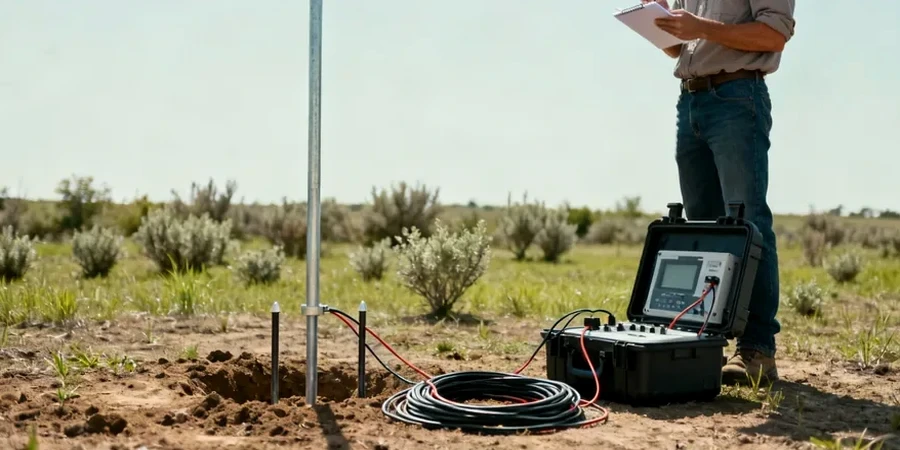
The AGI SuperSting R8/IP unit is a common sight on our project sites around Madison. We deploy a multi-electrode cable, lay it across the glacial outwash plains near the Yahara River, and run a dipole-dipole array to map subsurface resistivity contrasts before any excavator breaks ground. The logic is simple: different materials resist current flow differently. Saturated silty clay from the old Lake Yahara basin reads low resistivity, while dry sand and gravel terrace deposits push readings higher. For deeper targets—like mapping the top of the weathered sandstone bedrock beneath the east side—we switch to a Schlumberger VES spread, expanding electrode spacing step by step to build a layered resistivity model. In a city where the geology shifts from marsh deposits to glacial till within half a mile, this approach gives us a continuous profile that auger borings alone cannot match, and it pairs well with a CPT program when we need to correlate resistivity with cone tip resistance in transitional soils.

In glacial lake plain settings like Madison's isthmus, a 2D resistivity line can delineate organic silt pockets that standard borings miss between grid points.

Our service areas

Our approach and scope

Madison’s expansion onto the Yahara chain of lakes has created a patchwork of fill, peat, and natural alluvium that challenges conventional site investigation. What we see in the isthmus neighborhoods is a legacy of urban growth built directly over former wetland basins—ground that electrical resistivity can characterize without triggering settlement in sensitive organic layers. A 2D resistivity line run across a vacant lot on the north side typically resolves three things within an hour: the thickness of recent anthropogenic fill, the transition into natural lacustrine clay, and the depth to competent glacial deposits or sandstone. For projects near Lake Monona, where fluctuating water levels keep the upper 8 to 10 feet nearly saturated, the contrast between wet clay and underlying till is sharp enough to map with 5-meter electrode spacing. We often combine this dataset with MASW surface wave profiles to layer shear wave velocity over resistivity, building a more complete picture of stiffness and saturation before foundation design decisions are locked in.
Electrical Resistivity Surveys & VES Testing Across Madison
Technical reference — Madison

Local geotechnical context

The freeze-thaw cycle that grips Madison from November through March creates a high-resistivity frozen crust that can mask underlying conductive layers. Running a resistivity survey in February without accounting for frost penetration of 30 inches or more leads to misinterpretation of shallow fill and groundwater depth. We schedule most surveys between April and early November, or we install electrodes below the frost line when winter work is unavoidable. The other persistent challenge is cultural noise: buried utilities along East Washington Avenue, underground steam tunnels on the UW campus, and stray currents from light rail infrastructure all introduce noise artifacts in the resistivity data. Our processing workflow applies notch filters and bad-datum removal to clean up these urban signatures, but it is a factor we flag early in every Madison project—especially downtown, where the utility corridor density is among the highest in the state.

Need a geotechnical assessment?

Reply within 24h.

Email: contact@geotechnicalengineering1.org

Reference standards

ASTM D6431-18 Standard Guide for Using the Direct Current Resistivity Method for Subsurface Site Characterization, ASCE 7-22 Minimum Design Loads and Associated Criteria for Buildings and Other Structures (seismic site class determination), IBC 2021 Section 1803 geotechnical investigation requirements, ASTM D5777-18 Standard Guide for Using the Seismic Refraction Method (complementary when paired with resistivity), WisDOT Geotechnical Design Manual Chapter 4 (subsurface exploration methods)

Reference parameters

ParameterTypical value
Typical array configurationWenner or dipole-dipole, 56 to 112 electrodes
Maximum investigation depth (2D)Up to 90 ft with 10-ft electrode spacing
VES maximum depth (Schlumberger)150 to 200 ft in favorable sandstone terrain
Data acquisition systemAGI SuperSting R8/IP, 8-channel
Output deliverables2D resistivity tomograms, 1D VES layered models, pseudosections
Typical line length370 to 820 ft per setup, extended by roll-along
Applicable ASTM standardASTM D6431-18 for surface resistivity imaging

Frequently asked questions

What does an electrical resistivity survey cost for a typical Madison residential lot?

For a standard residential parcel in Madison—say a quarter-acre lot on the near east side or in the Monona area—a single 2D resistivity line with 56 electrodes generally falls between US$570 and US$980. The range depends on line length, electrode spacing, and whether we are also running a VES sounding for deeper bedrock confirmation.

How deep can resistivity imaging see in glacial soils like those in Dane County?

With a 112-electrode array spaced at 10 feet, we can image approximately 90 feet deep in typical Madison glacial deposits. For deeper targets—the sandstone bedrock surface on the east side, for example—a Schlumberger VES sounding can reach 150 to 200 feet, though vertical resolution decreases with depth.

Can you run resistivity surveys on frozen ground in winter?

We can, but it requires extra steps. Madison frost depth reaches 30 to 36 inches in a cold winter, and that frozen layer acts as a high-resistivity barrier. We either pre-drill electrode holes below the frost line or postpone acquisition until thaw. If winter data is critical, we flag the frozen crust effect in our interpretation report.

What information does resistivity provide that a standard boring does not?

A boring gives you a point measurement at one location. A resistivity line gives you a continuous cross-section between borings, revealing lateral changes in soil type, buried channels, or contaminant plumes that a drilling grid might miss. In Madison’s isthmus fill zones, we routinely map organic silt pockets and old buried stream channels that sit between boring locations and would otherwise go undetected.

Location and service area

We serve projects in Madison and surrounding areas.

View larger map